Saturday, July 16, 2016

How to Replace Motorcycle Sprockets and Chain

Tools needed include drill with grinder head, chain breaking and riveting tool (blue box in the centre), torque wrench.
I decided to replace my F700GS chain, front and rear sprockets myself. The OEM endless chain gives 31,600 km service, which wears faster than my expected 40,000 km service. I often ride two-up with my wife, and this load factor might reduce the lifetime.

To have a certified mechanics replace the chain and the sprockets would cost about $190 (i.e., a 2-hour job). To do it myself I bought Motion Pro's Chain Breaker and Riveting Tool for $160 (in Canadian dollar; it should be much cheaper if bought in US, even with US dollar). Wheel-bearing grease costs $6, and ceramics grinder head $6, so the saving isn't much if I intend to do it once. The saving I want to make will be realized if I replace the chain myself at least twice; it's both tool and skill investment.

I read this useful website to learn about chain replacement without sprocket replacement, in addition to information from the instruction manual of the Tool.

Other tools needed are goggle, grease, torque wrench drive, wrenches of required sizes, sockets of required sizes, ceramics grinder head, drill, screw driver. A caliper is optional, but it is essential if complete agreement between measured rivets' flare width and the chain manufacturer's manual is required.

The numbered steps below are chronologically arranged and do not give detailed step-by-step instructions which are provided by the Tool instruction manual. These 14 steps are proven to have worked for my case. They give the major steps and are best followed in conjunction with the manuals of your motorcycle, chain manufacturer, and chain breaking and riveting tool you use. They suggest that motorcycle chain replacement and sprocket replacement is a complicated procedure and may be best performed by a certified mechanics if you aren't sure.

First step: Open the front sprocket cover using Torx wrench.
1. Open front sprocket cover and chain guard to help smooth the chain removal process later. They are usually held by screws.

Count the number of outer side plates of your chain. Use a Sharpie marker to mark the chain numbers. There are two chain side plate types in a chain: outer (O) and inner (I). To verify your count, repeat your first count and accept the number if it is repeated. For BMW F700GS, the number of outer side plates is 58. There are therefore 58 inner side plates. There are 2 x 58 = 116 riveted pins therefore in the chain.

Rear (left) and front (right) sprockets are now exposed. Chain is crooked due to kinks.
2. Use the grinder head to grind off one rivet of any pin connecting two side plates of the chain. Only one rivet needs to be ground off for breaking the chain. This step reduces mechanical stress to the chain tool's breaking tip when pushing the pin. Wear a goggle to protect your eyes from flying steel debris.

Grinding to remove the rivet of a pin helps reduce the breaking tip's mechanical stress.
I find the grinding step indispensible to ease pushing the ground pin out using the Tool as described in Step 3 below. In my opinion, since my original OEM chain pins are slender solid steel rods, it would be impossible to push out the pin if its rivet is not ground off; it will rupture the breaking tip of the Tool.

The chain breaking & riveting tool here is configured to push out the unriveted pin.
3. Use the Motion Pro's Chain Breaker and Riveting Tool to break the current chain. Please refer to its instruction manual for more detailed step-by-step instruction on how to use the Tool to break the chain. Basically, its breaking tip, when the Tool pieces are correctly assembled, is used to push out the unriveted pin so that the chain links are broken and can be removed.

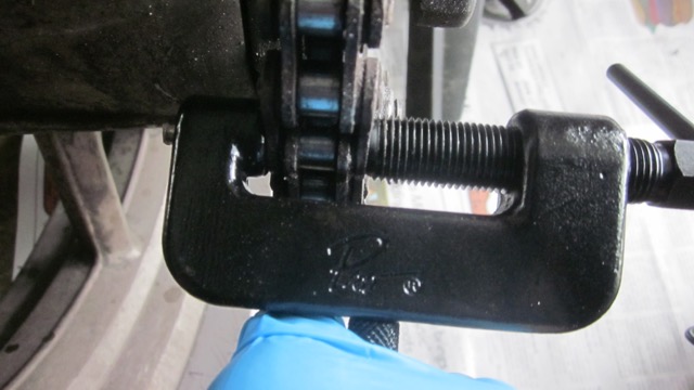
The pushed pin is visible on the upper left edge of the vice body. The pin can be pushed only after its rivet is ground off.
4. Remove the chain by rolling it off the front and rear sprockets. Be careful not to have your fingers caught between the chain and a sprocket.

5. Put the broken chain and the new chain side by side on newspaper sheets. This is to make sure that the length of the new chain together with the master link is the same as the broken's. The new chain is almost certainly longer than the broken and therefore needs to be cut to have exactly the same length. If a cutting mistake results in a shorter chain, a new chain needs to be purchased.

Repeat counting the number of outer side plates of the broken chain. The number should confirm the previous number from Step 1. 

There are two chain side plate types in a chain: outer (O) and inner (I). Their sequence in my new chain is I-O-I-O-I-O-I-...-O-I. (To form a chain, the first (I) and the last (O) side plate have to be different so that they can be linked together.) Because the master link is of type O and is initially separate from the new chain, the new chain needs to be cut to give exactly (i) the sequence I-O-I-O-...-O-I and (ii) one O-type side plate fewer than the number of O-type side plates of the broken (old) chain. The master link is then used to connect the resulting sequence I-O-I-O-...-O-I from the cutting in order to form a chain.

For example, my new chain has 59 outer side plates and 1 O-type master link. Because the broken chain has 58 outer side plates, I have to remove 2 outer side plates from the new chain to give me 57 outer side plates. The master link then makes the total number of outer side plates 58.

Note that both words "link" and "side plate" refer to the same object. The total number of side plates is therefore equal to the number of links in a chain. The number of pins is also equal to the number of links.

6. Grind off the rivet of the correct pin so that the cut new chain has (i) I-O-I-O-...-O-I sequence and (ii) one O-type link plate fewer than the number of O-type link plates of the old chain. Use the Tool to push the unriveted pin out, and thus cut the new chain into two parts. Discard the shorter part (and make a nice key chain out of it.)

7. Remove the current front sprocket from its shaft. It is usually held by a bolt which can be loosened using a torque wrench. Clean the area around the shaft to prepare for the new front sprocket installation. Install the new front sprocket by applying the correct amount of torque as specified by your motorcycle manual -if available- to tighten it using torque wrench.

Installing the new front sprocket. Washing the front sprocket area with water removes accumulating oil and dirt cakes. It's important to remove the water using oil penetrant so that water is not present in the crevices and there will be low corrosion risk.
Old (left) and new (right) front sprockets. The old sprocket's cogs are worn out.
8. Remove the rear tire (which includes the wheel, i.e., rim, that the rear sprocket is bolted to) as per your motorcycle manual. Make sure to properly disconnect speed sensor cable and to not scratch the brake disc by resting the tire flat on wooden bars.

Rear tire unit has to be removed so that rear sprocket can be accessed and replaced. Follow your motorcycle's manual on how to remove the rear tire unit.
Place the rear tire unit on top of wooden bars to prevent the brake disc from getting scratched.
9. Remove the rear sprocket from the wheel. Install the new rear sprocket by applying the correct amount of torque as per manual to tighten it using torque wrench.

New (left) and old (right) rear sprockets. 
10. Install the rear tire with the new rear sprocket back as per manual. At this stage do not tighten the rear axle bolt yet. You will need to push the rear wheel forward when connecting the cut new chain using a master link.

The rear wheel installation takes a lot of time for me due to aligning the brake disc, rear axle, and spacers. It is helpful to have another person help insert the rear axle. My son helped me in this step. We had a great father-son conversation (shop talk) while working together. Unforgettable!

11. Wrap the still-unconnected new chain around the new sprockets. Ensure that the upper part of the wrapped chain between the front and rear sprockets is as tight as the old one.

The chain breaking and riveting tool is now configured to push the master link's side plate.
12. Connect the new chain using the master link. This step also requires assembly of the master link's parts (o-ring seals, side plates) correctly, as per chain manufacturer's manual, when connecting the new chain. Use the Tool to press the master link's side plate. The Tool piece assembly for this step is different from the chain breaking assembly, as per the Tool manual.

It is best to press the side plate in several slow steps. That way you can inspect and slowly increase the amount of protrusions (flares) of the pins.

13. Assemble the Tool pieces, as per Tool manual, so that the Tool is now used to create rivets from the two hollow pins of the master link. The plugged end of each pin should be at the inside (facing away from you) of the chain. The open end which will be flared by the Tool to form a rivet, is at the outside (facing toward you) of the chain.

In my case the master link's pins have a pre-installed side plate, so I don't have to worry about identifying the plugged and the open ends of the pins.

This step is critical since the amount of flares determines the mechanical integrity of the chain. A flushed flare with the side plate may crack the pin. Not enough flare will not hold the side plate solidly in place. As an important option: use a caliper to correctly determine the amount of flare by taking the difference between the flared pin's diameter and the unflared pin's diameter.

Once the push bolt of the riveting tool feels tight, I apply 3/4 of a turn to produce each rivet. Repeat this step for the second pin. I press the riveting tool twice for each pin to produce the rivets on the two pins' heads.

This is the verbatim safety warning from the Motion Pro's Chain Breaking and Riveting Tool's manual:
* It is very important that chain master links be clipped or riveted properly. Improper installation can lead to great bodily harm or death. If you are unfamiliar or uncomfortable with this process, please have your work supervised by a qualified technician or bring your vehicle to a qualified facility for repair.


Quality of the rivets of the master link by following the steps outlined in this blog.
14. Turn the rear wheel to make sure that the chain runs through the sprockets without intermittency. Adjust the chain sag as per your motorcycle manual. Install the front sprocket cover and the chain guard.

Sunday, July 10, 2016

Touring Motorcycle Requirements

Chain maintenance during a long-distance touring is a daily chore. Chain sagging occurs after kinks are observed in chain links.
I just got back last week from a 3-week, 8700-km motorcycling trip from Calgary to New Orleans return. The long distance covered requires that I ride about 620 km every day in the 14 riding days I had. I rode with my wife and 4 bags, including a tank bag, so that our total payload is about 210 kg.

We rode under various weathers, from 5 to 40 degrees C, from monsoon rain to hot sunshine. The coldest riding days were in Southern Alberta and around Glacier National Park, Montana, while the hottest riding days were in Texas and Louisiana. We experienced monsoon rain in Metairie, just west off New Orleans, and the best riding conditions (25 degrees C, still air, sunshine) in New Mexico - Texas border and Southern Utah.

My motorcycle is BMW F700GS, which has an 800 cc engine, a maximum rated 75 hp power at 7300 rpm, and a maximum rated 77 Nm torque at 5300 rpm. The maximum payload it can have is 227 kg, so our payload is close to the maximum allowed. My average highway speed is 70 mph (112 km/h) during the trip, which was 1/3 of the time felt inadequate, especially on interstate highways that have 80 mph speed limit. I can push my motorcycle to 150 km/h (94 mph) when overtaking trucks or RVs, but it's having a hard time sustaining a 75 mph average speed or higher with our payload in order to keep up with fast-moving interstate highway traffic. The maximum 0.18 hp per kg of total mass (both payload and motorcycle's mass of 200 kg) proves 1/3 of the time inadequate.

The horsepower per kg (i.e., power to weight ratio) is a good measure to use as it factors in motorcycle's mass, payload, and power output. For example, if I ride by myself, the figure of merit changes to 0.25 hp per kg, representing a 38% improvement over a two-up. Because drag force only depends on surface area, which is constant regardless whether it is a solo or a two-up, and speed, then I expect to be able reach an 80 mph average speed when I am riding solo.

The only solution to improve the 0.18 hp/kg number is to change a motorcycle with a larger engine displacement. The larger hp/kg requirement doesn't mean that sports bikes, like BMW S1000RR, are good choices. Even though S1000RR has a 0.48 hp/kg power to weight ratio, which is a fantastic improvement over my F700GS, it doesn't have the correct riding posture for a multi-day touring. The upright riding posture of the BMW GS models fits best for the multi-day touring. My back and arms didn't feel sore at all after straight 7 days of riding, covering 4500 km. Other adventure touring motorcycles, such as Yamaha Super Tenere and Suzuki Strom, will fit best too.

Beside power-to-weight ratio and riding ergonomics, I find power transmission drive type matters as well. The chain drive of F700GS requires daily maintenance because I cover about 620 km every day. (Normally, chain links need to be cleaned and lubricated every 500 km.) I had to clean and lubricate the chain in the morning before we rode. Because we do 8-10 hours of riding, we're tired by the day's end, and the morning cleaning ritual works well. My motorcycle chain was stretched at the end of our trip (see photo). Next time I will have to bring a spare chain and rear sprocket pair for such long distance touring.

Shaft power transmission drive will not require daily maintenance and in my opinion is the ideal drive type for a long-distance touring. Some adventure touring motorcycles, even Honda Africa Twin CRF1000L, have chain drive; although chain drive is lighter, I have to wonder whether the rigor of chain drive maintenance might interfere with the trip enjoyment. I know it did in my case. My left thumb was almost crushed by the rear sprocket when I was cleaning it.

After power-to-weight ratio, riding ergonomics, and power transmission drive type, the fourth requirement is wind (rain) protection. During our trip, we experienced high crosswinds in Texas - New Mexico border along I-40 and in Highway 2 around Cardston, Alberta. A tall front windshield will remove most of the wind problems. When I started riding 2 years ago, wind protection was my main concern, but as I get used to handling crosswind forces, I now think that the tall windshield is good enough. A full fairing that protects the entire arms, body, and legs is better of course, but it's not necessary since quite often rain doesn't occur throughout the trip. I find that rain does occur within 10-15% of the time.

The most important requirement is in fact riding ergonomics. Fatigue and soreness in arms and back are no option for riders going long distance. That's why I hesitate if I should ride Yamaha FJR1300 even though it satisfies power-to-weight ratio to give an 80 mph speed average, power transmission drive type, and wind protection. FJR1300 riding posture is bending forward, more sports-bike. One other factor, though optional, is the off-road capability. I like F700GS because it allows me to ride on gravel roads to a campground or a hiking trail. I didn't have this experience in our New Orleans trip, but it occured in previous trips.

The next important requirement is power transmission type. Chain maintenance requires 1 hour per day and requires one to carry chain cleaning and lubrication tubes, in addition to spare chain and sprocket. This may actually be acceptable for some riders who ride around the world and value easy repair of chain drive. I happen to think, however, that shaft drive is better. My next motorcycle will have to have a shaft drive.

Power-to-weight ratio is the third important requirement. F700GS is actually fine power wise if I don't mind with a 70 mph average speed. It will still take me where ever I want to go. If I encounter a faster speed limit in a highway, I simply exit it and use a secondary highway. The power-to-weight ratio is an ego thing - somewhat.

The touring thinking I outline could explain why BMW R1200GS is so popular. I would like to have such machine, but it's so expensive. Yamaha Super Tenere offers much more reasonable price and arguably better reliability. That's a decision process I have to go through.

Friday, July 8, 2016

Great Falls, MT - Calgary, AB Motorcycling

Clouds gathered in Lethbridge, which made us postpone our lunch stop until we reached Vulcan.
86. Our ride home to Calgary from Great Falls on Wednesday, July 6 wasn't without challenges. The main challenge is the high probability of thunderstorms in Southern Alberta, where Calgary is located. Our sons told us that Calgary was having a lot of rains when we're in the States. This piece of information is what made me decide to ride a longer-than-usual 840 km from Brigham City to Great Falls the day before, with a purpose to create a time slack for the Wednesday ride in case we get caught in thunderstorms. If things go well, the 520 km distance between Great Falls and Calgary should be completed in less than 5 hours of riding. But if we are caught in thunderstorms along the way, we're mentally prepared to wait out for 3-4 hours or even to stay overnight in Lethbridge or Fort Macleod.

87. The second challenge is the average 15 degree C ambient temperature, which on its own is okay. 15 degree C is in fact a pleasantly cool riding temperature. It will, however, give a really cold riding condition if rain comes down as well. We've experienced such condition before in September 2015 when we rode back from Nelson, BC. Knowing this, we'd like to avoid having rain and cold temperature when we ride.

88. As soon as we left Great Falls, heading north on I-15, we're surrounded by dark clouds. Water droplets start forming on my helmet visor around Conrad, MT. It disappeared before Shelby, MT, where we stopped to refuel. There were not many gas stations between the 300-km stretch between Great Falls and Lethbridge, AB. Besides, refueling in Shelby is the last opportunity we have for a low gasoline price.

89. Dark clouds kept shadowing us between Shelby and the Canada - US border in Coutts, AB (or Sweet Grass, MT in the US side). The sky cleared a bit before Lethbridge, but unsettling sky surrounds us again when we reached Lethbridge. We decided not to stop in Lethbridge although we were hungry. Dark clouds toward Fort Macleod made me take Route 23 northbound to Vulcan where we stopped for 20 minutes for lunch and refueling. Route 23 turns westbound north of Vulcan, which takes us to Highway 2 junction. I rode as hard as I could to avoid getting trapped in a thunderstorm. Try as I might, we finally got drenched in rain as we entered Deerfoot Trail north of Okotoks. My wife was elated when we entered Calgary; that gave me a push to complete our ride safely home.

Rain finally caught us as we entered Deerfoot Trail north of Okotoks. It cleared once we were around Cranston area.

Thursday, July 7, 2016

Brigham City, UT - Great Falls, MT Motorcycling

There are some big downhills on I-15 northbound between Butte and Helena.
80. Today's ride (Tuesday, July 5) is the farthest we've done so far in one day. We covered 840 km in one day on I-15 northbound from Brigham City to Great Falls. To do it two-up and cover such distance require good planning. First, we have to start riding at 8 am, even though the weather is cool 18 degree C in Brigham City. The main reason is to cover 1/2 of the distance before our lunch. Second, the average speed needs to be about 70 miles/hour (112 km/hour), so that we can achieve the distance in less than 12 hours including stops and lunch. This requires travel in a highway not too crowded with vehicles, in a day not too windy nor rainy. My motorcycle doesn't have a 1000+ cc engine to reach a higher average speed, so I have to rely on favorable riding conditions. We check the temperature, rain forecast, and wind speed forecast in the morning before we ride. This prior check gives me a way to predict if the distance target is too much or not.

81. Having a ride partner helps me carry my riding days. My wife and I divide tasks. She takes care of the luggage: 2 side bags and 1 top rear bag. Organization is important. She keeps the riding-day necessities in the top bag: extra clothing and gloves, instant noodles, a thermos with steamed rice, motorcycle tools, tire pump, tire brush cleaner, laptop bag, toilettries. The 2 side bags are for stainless steel bowls, eating utensils, a small pot, clothing, which we don't carry a lot of, a tent, a stove, and a 2-liter jerry can filled with gasoline. She carries essential body care and cosmetics. We rely on layered clothing to accomodate temperature range of 5 to 40 degree C: light vest, light wool long sleeve sweaters, sleeveless shirts (tank tops), light thermal jackets; all of these clothing, if worn, have to go underneath our weatherproof riding jackets. I organize the ride planning and route.

82. We plan for 3 refueling stops: Idaho Falls, Dillon, and Helena. The distance between Brigham City and Idaho Falls, ID is 260 km, and I have to cover it in under 3 hours. By starting at 8:15 am, we were riding on a quiet highway; there were few cars so I can ride with a 70 miles/hour average. The wind is calm and there was no rain although it was cloudy. We arrived in Idaho Falls before 11 am. I saw a travel advisory notice just before Idaho Falls, and we were expecting a high wind status. The second stage to Dillon ride was rather numbing. Highway was so quiet; we were often alone for many miles. Scenery doesn't change as often and is similar to Wyoming. My wife was having a period so we had to stop earlier in Lima, MT, an almost-alpine small hamlet, where an I-15 rest area is located. Our motorcycle almost tipped over when she got on the motorcycle after our bathroom breaks. A second close call when the motorcycle is not in motion. We decided not to stop in Dillon to save time and finally stopped in Butte, MT, about 180 km north of Lima. We experienced high wind gusts between these two stops. I was hungry too and still perturbed from our close call, so the lunch stop in Butte was quite welcoming.

83. Motorcycling requires an adapt-and-adjust attitude. It's much easier to travel in a car. We both enjoy motorcycling because in this modern world it's probably one of the last real adventure options we can have. Bicycling is more grueling and more adventurous as a result; I have tried it before, but it's much too slow. I can cover 600 - 800 km in a motorcycle but can only cover 100 km in a bicycle per day. I cannot take my wife as well if I pedal my way to New Orleans; it will take me 2 months to complete our Calgary - New Orleans trip.

84. After a good lunch, I got sleepy as we rode to Helena from Butte even though it was only 100 km. Our Plan A is to stop in Helena and continue the ride the next day. After having a coffee in McDonalds, I felt better. I decided to continue riding for 150 km to Great Falls. My wife felt okay too. So away we went. The scenery between Helena and Great Falls is rewarding, and I didn't feel tired nor sleepy along the way. It was quite windy when we left Helena, but it went quieter further toward Great Falls.

85. We arrived in Great Falls at 6:30 pm. We managed to cover 840 km in 10 hours including stops. It was a great riding day since it shows us that we can cover more than 800 km in one day. I was happy especially for this since any preconceived notion of set 600 km daily target can be bad for my mind. When I'm afraid of breaking my own comfort zone, then my mind becomes paralyzed. It is a good day for us precisely because we were able to change our comfort zone and let it remain flexible.

Along the construction zone on I-15 between Helena and Wolf Creek, we spotted beautiful corners of Missouri River.

Blanding, UT - Brigham City, UT Motorcycling

Price has one of our best-kept secrets: All-you-can-eat $6 Pizza Hut.

73. We left Blanding in the morning on the Fourth of July (Monday) and saw people fill up the sidewalk of its main street for the parade. I waved at the kids from the motorcycle, and their faces seemed to ask if the parade were starting already. Blanding is a quaint pretty town situated in the one of the most scenic area in the Southwest US. To its east, it's the Million Dollar Highway, also known as Route 550, that tempted me to ride all the way to Grand Junction, CO. I stopped the day before in Bloomfield, on Route 550, and headed west on Route 64 to Shiprock and then Blanding. To its west lies the Grand Canyon, which we didn't go since we've gone there before. To its south, it's the Monument Valley that we visited the day before.

74. And to its north - well - it's Canyonland National Park, Arches National Park, and Moab. The ride along Route 191 from Blanding to Moab is beautiful. Moab resembles - as we find out - Canmore, a staging ground for outdoor activities. The landscape of Southern Utah, between Blanding and Moab, is - again - simply beautiful; the landscape changes from hilly treed roads to farmland near Monticello to rocky semi-desert as we neared Moab.

75. The 100-km stretch between Moab and the I-70 junction is a straight, busy, fast road. It's a rather frustrating stretch for motorcycles since the road is narrow and there are many RVs that clog the one-way lane. Patience is required when I encounter a changing road environment like this. I mentally note of this change, the same way I do when I enter a big city. Road suddenly becomes crowded and slows down. If I am careless, these changing environments can be deadly. For example, I notice I have a tendency to overtake several vehicles at once when the opposite lane is empty. Although I do this safely, the consequence of overtaking several vehicles at once is to keep riding fast. To get away from them as far as I can, so that I don't end up with the crowded convoy tailing me. If one of the vehicles follows suit, then this might turn into a two-vehicle road race. When this happens, it can turn to a stupid road pursuit, and I just have to tell myself to allow the vehicle to overtake me. I have to remind myself - when this situation occurs - that my engine is only 800 cc.

76. I-70 gives a haunting feel. White rocks line both sides at far away; it almost suggests that dinosaurs might just arise out of nowhere and chase us. There is no greenery to hide, and it will be a scary blast to ride if the wind is screaming. We're lucky wind doesn't blow much today. Cars move so fast in this interstate highway; 85 miles/hour is their average speed. My motorcycle is struggling to keep up; it gets buzzy above 75 miles/hour. Out of the interstate highways we travelled so far - I-15, 90, 25, 40, 49, 10, 20, and 70 - I-70 is definitely it.

77. Seven miles west of Green River, UT where we stopped for refueling, we left I-70 for Route 6. This is a welcome change. It still feels haunting with the white rocks staring at us cold. But this route is made for motorcycling. A hilly road with enough twists to favor motorcyclists. Enough number of passing lanes to pass RVs. Some 125-km later, we stopped for lunch in Price, UT. The town's name suggests it's a good town to stop. We ate at Pizza Hut for an all-you-can-eat $6. Where can we find such a bargain in Canada, we asked. The waiter is courteous and has great tattoos on his arms. I was tempted to ask where he got them from. I was tempted to eat as much as I can too. But I'm riding, so I stopped eating earlier.

78. North of Price, along Route 6, the road becomes even more twisty and uphill. Southern Utah again shows its beauty. Clouds were gathering, and I rode as hard as I can, to get away from them. I watched the sky as I rode. I tell the clouds to not get near me. Drizzles came down in a few minutes, and then they went away. On and again. Near Spanish Forks the rain threat went away. The sun greeted us again. We were relieved.

79. We entered I-15 northbound, south of Provo. The highway city traffic is fast, and I was happy to oblige. American motorcyclists are polite and civil, and fast as well. We've had a great experience riding in its interstate highways. Our best Fourth of July experience. We arrived in Brigham City at 6 pm to rest, after covering 600 km. And I finally get to stop in a carwash to properly clean my motorcycle chain. One of the best riding days.

One of beautiful many rock formations along Blanding and Moab.

Wednesday, July 6, 2016

Albuquerque, NM - Blanding, UT Motorcycling

On I-40 westbound in Albuquerque, before heading north on I-25.
66. My left thumb was almost crushed by rear sprocket and chain when I was cleaning the chain before we rode to Blanding, UT. I had no access to a water hose to rinse the chain after cleaning it using a cleaning solution, so I had to use my hands to remove dirt-oil cakes accumulating on the chain link. My perfectionist streak almost got me into a serious accident - when the motorcycle is not moving at all - 2400 km from home.

67. On Sunday, July 3 we rode from Albuquerque, NM to Blanding, UT. It's a 12-hour ride covering 675 km since we visited Monument Valley at the Utah - Arizona border as well. Planning today's route took me the longest time since there's no direct route to the Monument Valley (MV) from Albuquerque. Approaching MV from the south would require us to reach Kayenta, AZ, which is about 480 km from Albuquerque off Gallup on I-40 westbound. Our daily budget of 600 - 700 km, therefore, would require us to stay overnight in either Mexican Hat or Bluff, both in Utah. This is not good from budget perspective since lodging in either town would cost around US$120 due to the touristy location, a price too steep in my opinion.

68. In addition to distance and budget, I have to account for the gas station locations along the way if the route is remote, which is the case for the MV. The maximum distance of the 16 liter of gasoline in the tank is between 288 and 352 km depending on speed. To prevent running out of gasoline in a remote spot, I usually fill up every 150 - 200 km. (Along interstate highway, the fill up distance can go up to 285 km, as it happened between Casper and Cheyenne in Wyoming.)

69. Considering these, I picked Blanding, UT as our destination. Blanding is about 100 km north of MV, which requires me to ride south to MV and then ride north on the same road to head north. Motel rate in Blanding is much cheaper than in Mexican Hat or Bluff.

70. We started from Albuquerque on I-40 westbound for 6 miles and changed to I-25 northbound in the city. We then changed to Route 550 northbound. This turns out perfect because Route 550 is both scenic and a divided highway. We reached Bloomfield, which is about 280 km from Albuquerque, in 3 hours with one refill stop. From Bloomfield, we took Route 64 to Shiprock, and then on to Route 160 in a small hamlet of Teec Nos Pos, and then Route 191 northbound to Bluff. The stretch of Route 64 between Shiprock and Teec Nos Pos is bumpy and narrow, but the winding road offers a rewarding scenery.

71. We managed to reach Bluff at 15:30 by starting from Albuquerque at 08:30. The fast ride along Route 550 now gives us a chance to take a south dip to MV in the same day. And we don't have to pay a steep motel rate as well. MV area is a breathtaking beauty. Rocks are gleaming red under sunlight. Rock piles and formations look like being placed on a vast flat surface by an ancient giant. They give a haunting effect, and it's clearly a highlight of our motorcycling trip.

72. Our stay in Blanding, UT turns out great as well. There is a great little Mexican restaurant, Dos Amigos, nestled inside the 7-Eleven gas station, that I highly recommend, It's run by a young team and has a tasty chimi plate for $10.

Monument Valley as viewed on Route 163 southbound. It's a place worth visiting.

Sunday, July 3, 2016

Childress, TX - Albuquerque, NM Motorcycling

Welcome to New Mexico gate at the I-40 westbound as we crossed from Texas.
60. We felt a great relief leaving Texas scorching 39 degree C weather when we entered New Mexico on I-40 westbound on Saturday, July 2. The temperature drops to around 28 degree C. But it wasn't without a trade off. The route along Route 287 and then I-40, between Claude, TX and Santa Rosa, NM, which is about 320 km, is the windiest corridor I've ever experienced. It feels at times windier than the Crowsnest Pass on Highway 3 at the Alberta - BC border. North of the I-40 corridor between Amarillo and Texas - New Mexico border, there are literally hundreds - if not thousands - of wind turbines. We covered about 640 km from Childress, TX to Albuquerque, NM.

61. While the crosswind direction is consistently one-directional between Claude and the Texas - New Mexico border, the crosswind direction is random between the border and Albuquerque. We stopped for lunch in Tucumcari, at the Love's Travel Shop to get our favorite fried chicken and baked beans, and for refueling after a straight 182 km ride from Amarillo. I thought the stop would energize me to ride all the way to Albuquerque, but it turned out not to be the case. We stopped again in Santa Rosa, a mere 96 km from Tucumcari, because I was tired from the random crosswind. I used this second stop to refuel and relax, since there was still 185 km from Santa Rosa to Albuquerque.

62. I learned so much from our motorcycling trip. It teaches me fortitude and humility. Every night we get to plan our next day ride (about 600 km). I check weather report, route plan, and more importantly prepare mentally for the ride ahead. If the motorcycle is in good condition, then the next critical thing is to have a mental fortitude to handle all conditions and uncertainties on the road. The need to adjust the ride distance according to these conditions erases any cockiness that may come from the safe mileage we have accumulated. Bravado on the road can lead to unsafe riding, which quite possibly leads to fatality. I submit that a quiet, determined mind is the only attitude that can save me. Most experienced travellers in fact develop this attitude regardless of transportation means; they're quite often never the loud and giggly type on the road.

63. It was in New Mexico when I first saw a person casually carrying a gun in a holster, having his meal in a restaurant. He's not a police nor a security guard, so this was my first concealed weapons example. I think there is a correlation between politeness and concealed weapons law. People we meet on the road are very polite to each other and give a clear impression not wanting to meddle with someone else's business. This behavior is uniform across the western states we've visited so far: Montana, Wyoming, Colorado, New Mexico, and Texas. I would add that Alberta is no difference. I like the western sense and sensibility; we are polite, reserved, and down-to-earth.

64. We're not the only "crazy" motorcyclists that go long distance. I met two guys in our motel in Childress, who rode from Florida to Glacier National Park, and back. I met a quiet guy with clear tanned lines of riding without a full-face helmet from Albuquerque to Chicago, and back.

65. Albuquerque is a beautiful city. It is dotted with many hills at its eastern end. The hills are filled with small trees that form almost a lattice. The city and surrounding area must receive enough rain to sustain these trees. The I-40 westbound turns into a long descent into the city. We saw houses perched above many hills.

Though rain poses a greater riding challenge, severe crosswind comes close second. One easy way to tell a severe crosswind area is to see wind turbines along the way. Get ready to adjust riding stance to ensure the bike is moving smoothly under severe crosswind.

Saturday, July 2, 2016

Longview, TX - Childress, TX Motorcycling

Motorcycle convoy can be joyful and stressful.
55. As soon as we rode back along I-20 westbound toward Dallas from our overnight stay in Longview, we were accompanied by 5 riders who rode together as a convoy. Group riding makes one feel better and safer. Up to a point, I find. Six of us formed a staggered riding position, and their ride leader decided most of the time to stay in the left lane. There were always trailer trucks on the right lane, and our average speed was above the 75 miles/hour limit. Occupying the left lane for a 10-minute stretch at a time for a 6-motorcycle convoy wasn't a good idea in the end for me; there were several cars and SUVs that moved faster than ours and weren't patient with us occupying the left lane. So I decided to break off from the convoy and slowed down.

56. Entering Dallas, I decided to take Highway 635 northbound and then 35E northbound to skirt the traffic congestion around the 35W and 287 connection near Fort Worth. We rode all the way to Denton on 35E, which was about 80 km along the route, and had to contend with continuous construction for that distance. It was quite stressful since I had to watch for road bumps and cracks, in addition to heavy Fourth of July weekend traffic. The opposite directions, all toward Dallas downtown, had much worse traffic congestions though.

57. One thing we learned in our long-haul riding is to not overeat during lunch. We stopped for gasoline and lunch in Denton. We ordered one plate of chinese food and shared it together. We bring a thermos filled with steamed rice. After lunch, we continued on Route 380 westbound and joined Route 287 northbound in Decatur. I stopped to have a half-hour nap in a rest area south of Bowie; I think the drowsiness came from a combination of the 39 degree C temperature and the lunch. It was a scorching hot riding day! We also stopped for rest room in a Walmart near Bowie. It gave us a chance to drink a lot of water before continuing riding.

58. I felt better after the nap in the rest area and replenishing the sweat that filled my jacket. We passed through Wichita Falls, Vernon, and finally stopped for rest in Childress. Wichita Falls has rather confusing highway exit connections since they curve several times inside the city. This can be challenging in a busy traffic. We stopped in Vernon for rest room again and refueling. We toyed with the idea of riding all the way to Amarillo, which was another 190 km from Childress. But our better judgment decided that it would be safe to stop in Childress. It was a good decision. We covered about 610 km between Longview and Childress on Friday, July 1.

59. Motorcycling brings conversation with strangers on the road. In Vernon, we had a great conversation with a Texan wrangler who showed us photos of Monument Valley and Mesa Verde. In Childress, one guy approached to tell me he brings a Ducati Monster on a trailer to Colorado to ride in the mountain. Especially, when they see our Alberta license plate and then think that we're crazy to ride all the way from Calgary to New Orleans.

Dallas traffic - or any big city traffic - is stressful for a guy who just wants to pass through.

Friday, July 1, 2016

New Orleans, LA - Longview, TX Motorcycling

The New Orleans thunderstorm caused us to stop for 90 minutes in Metairie, just west of New Orleans.
51. After spending 4 days in New Orleans attending and presenting my 2 papers at the American Society of Engineering Education's 2016 Conference, we're ready to get back on the road on Thursday, June 30 at 07:45. Weather forecast said there was a higher than 50% precipitation around New Orleans, but we didn't expect to get a monsoon rain (thunderstorm) for more than an hour, as we started to leave the city.

52. My helmet has a sun (dark) visor behind the outside protective glass. The heavy downpour filled the glass surface with water beads that severely reduced my visibility. On top of that, water started accumulating on the right lane of I-10 westbound, which signals the possibility of hydroplaning. So, I decided to exit the highway in Metairie. We initially were marooned at a gas station and then moved to a coffee shop nearby. The rain didn't stop until 90 minutes later. Our jackets and pants were completely wet. I ran into one guy who said humorously: Are you having a regret motorcycling today? I answered with a smile that I couldn't afford to have a regret since I still have 4000 km to go. He's planning to visit Niagara Falls (the more picturesque side in Canada) and Atlantic Canada.

53. After the rain cleared, another cloud formation was moving from the Gulf of Mexico. So I decided to outrun it westward – if I could. We're lucky that we arrived in Baton Rouge, about 100 km west of New Orleans without any more rain. We had to stop at the BMW Motorcycles of Baton Rouge to have my motorcycle's tires replaced. I thought this would be a good decision since the rear tire already had 2 plugs and could last a maximum 3000 km. I don't want to get stranded with worn out, punctured tires in a desert.

54. The 90 minute rain stop and another 2 hour stop in Baton Rouge made today the longest ride day. Total time was 12 hours from 7:45 am to 7:45 pm when we stop for the night in Longview, covering 640 km. We took Route 190 (Airline Highway) to get us to Opelousas, LA to get us back into I-49 northbound. The I-10 route between Baton Rouge and Lafayette was more picturesque, by the way. But the landscape between Baton Rouge and Opelousas, LA on Route 190 reminded us of Solo - Yogya route in Java, Indonesia. We stopped at our favorite gas stop in Natchitoches, LA, that sells delish, just-spicy-enough-for-motorcycling meat pies.  The ride between Alexandria and Shreveport was good, if not slightly boring after awhile.

Monday, June 27, 2016

Baton Rouge, LA - New Orleans, LA Motorcycling

The view along the bridge on Lake Pontchartrain shore on I-10 eastbound.
47. I decided to stay overnight in Baton Rouge, which is only about 100 km east of New Orleans. We had to wait until 13:00 the day before in Shreveport to have my motorcycle serviced. The 100-km remaining distance seems close and far since we want to savor the moment when we arrive in New Orleans on Sunday, June 26.

48. More importantly though my wife and I are frugal traveller. We take pride in traveling cheaply and adventurously. I thought that staying one more night outside our booked accommodation in New Orleans would be more expensive than what we're willing to pay in lest-touristy Baton Rouge. We've been staying in motels in small cities and towns from Calgary to Baton Rouge. They're cheaper than hotels in big cities, like Denver and Dallas, that we passed through. I have more to say about the tips surrounding finding a cheap, clean, and good quality motel in another blog.

49. We had to go to Mall of Lousiana in Baton Rouge to get a cable adapter for my conference presentation in New Orleans. The temperature was 37 degree C, so waiting for 30 minutes in an air-conditioned mall is a real luxury for us. After getting the cable adapter, we left for New Orleans along I-10 eastbound. The ride was good and steady at 110 km/h (with the posted limit of 60 to 70 miles per hour). We were greeted by a beautiful ride along the shore of Lake Pontchartrain about 15 miles before entering New Orleans.

50. The exit direction off I-10 was very clear. I have studied each important highway exit I took in our trip by viewing Google Maps, and this has prevented me from getting lost by taking a wrong exit. We're quickly led to Poydras St from the I-10 and found the street where we're going to stay not far from French Quarter. We're so relieved that the 4000 km journey from Calgary remains safe and celebrated by having a Po'boy and a Cajun catfish lunch not far from Jackson Square.

The precise and logical highway exit sign system in the US. The exit number corresponds to the miles number from the state border. In this case, this exit is 209 miles away along I-10 eastbound from the Texas-Louisiana border and is heading north.

Sunday, June 26, 2016

Shreveport, LA - Baton Rouge, LA Motorcycling

BMW Motorcycles of Shreveport.
40. During the long-haul Calgary - New Orleans road trip I'm constantly checking the cleanliness of power transmission chain of my motorcycle. Ideally, the chain needs to be cleaned and lubricated every 500 km, but doing this is practically impossible because we've been riding for 8-10 hours everyday for the past 7 days. We feel tired at the end of each day, and on the road it's not easy to spot a car wash for its water pressure washer. To solve this problem I carry a small WD-40 can and use it every second day.

41. After 3400 km from Calgary, the engine oil needs to be replaced as well. I bring with me an air filter wrench for this, so I went to BMW Motorcycles of Shreveport to purchase chain cleaner and lubrication sprays and engine oil. It's probably our lucky day since they can accommodate my motorcycle for a service with their mechanics, so I decided to have the motorcycle checked and serviced. They give a super-friendly service, and I was able to talk directly with the mechanics. I even got a free T-shirt. My tires are more than 50% worn, but they don't have Michelin Anakee 3 tires in stock. He told me that the chain links have some kinks and may have to be replaced in Calgary.

42. We met the sales and service manager and received good tips on Lousiana from him. Now we know the geographical locations of Cajun and Creole people of Lousiana. We learned to pronounce Natchitoches – an old city between Shreveport and Lafayette – and that Cajun people are descendents of francophone Nova Scotians who sailed and were rejected to land along the Atlantic coast until they reached New Orleans. He gave me places to check out for the Delta blues music in New Orleans.

43. We waited for 3 hours at the motorcycle dealership and started riding at 13:00. Luckily the distance between Shreveport and Baton Rouge is 400 km, so we reached Baton Rouge at 18:00 after stops in Natchitoches and Lafayette for lunch and gasoline. We took I-49 to go southbound from Shreveport to Lafayette, and then we changed to I-10 eastbound to reach Baton Rouge.

44. We enjoyed riding on about 20-km long (or maybe longer, I didn't check exactly) bridge network above Lousiana swamp (Atchafalaya National Wildlife Refuge). We crossed a Mississippi River bridge to arrive in Baton Rouge. It's a special place and is as distinct as riding in Jasper National Park. Now we know and experience ourselves places around Lousiana that we've seen in movies.

45. We had our first rain on the road just off Lafayette, as we entered the Lousiana bayou. Luckily it didn't last very long. Rain makes me more nervous than strong wind.

46. I am impressed by the exit numbering system of the US interstate highway system. It corresponds to the distance in miles from a state boundary and therefore helps me tremendously in locating an exit. I've never gotten lost from Montana to Lousiana – we'll see if the record continues until New Orleans – because I can use the total distance travelled information in my simple GPS unit to anticipate an exit a few miles ahead. The mile marker posts along the highway also help.

The bridge network above Lousiana bayou.

Saturday, June 25, 2016

Vernon, TX - Shreveport, LA Motorcycling

Heading to I-20 eastbound from 35W freeway in Dallas.
33. The 640 km ride between Vernon and Shreveport was highlighted by strong wind for the entire trip, hot (35 degree C) and humid weather, and the beginning of great Lousiana BBQ food.

34. We stopped in Bowie, a small cowboy town about 90 km east of Fort Worth, on Route 287 for DQ blizzard to cool down. We stopped at another DQ in Tyler, about 160 km east of Shreveport, to ward off dehydration. We spotted the DQ signs on the road and simply followed the directions in both cases. To get back to the highway, we ask the locals; quite often though the way back is self-evident. I use the GPS unit not to tell me where to go; I use it to check whether the route I planned the night before is being implemented on the road.

35. The construction at the end of Route 287 concealed the beginning of 35W freeway near Dallas. The ensuing traffic jam made the riding very uncomfortable: slow, hot, and thirsty. Luckily I already planned the route to reach the I-20 so that we didn't get lost by making a wrong exit.

36. The bad part though was the crazy-busy traffic around Dallas. There were so many trailer trucks that move at the highway speed limit of 70 miles per hour. Most truck drivers are good, but they block view, and when three or four of them are forming a convoy the traffic will definitely slow down as they choke one lane. More seriously, I counted about 10 incidents of car drivers changing lanes without giving any signs. They are concerning for motorcyclists since we're the weakest vehicles on the highway: we have no steel cages to protect us.

37. We accidentally found a great Lousiana BBQ - Dave's BBQ - in Duncanville, off the Exit 463 on I-20 eastbound. We were originally going to get Subway, but it was next door and quite inviting. We didn't make a mistake. The chicken BBQ smells very good and the baked beans is exquisite. One thing we really enjoy while in the US is the excellent sweet iced tea everywhere we go. It makes me forget how good hot coffee can be, as the iced tea is simply the best thirst quencher.

38. We learned that northern and eastern part of Texas, from Dumas to Marshall, is as flat as bread. There were not many picturesque camera shots along the way. We find more greenery as we neared Lousiana.

39. One Texan greeted me when I parked my motorcycle in front of Dave's BBQ. "Is that F800GS?", he asked. Then we had a 10-minute parking lot conversation on Kawasaki KLR650 he now owns and  his plan to replace it. At a gas station near Shreveport airport, another fellow – an airplane pilot – said he'd wish his motorcycle was a GS, not an RT. The two codes – GS and RT – refer to BMW motorcycle models, and then we had a 5-minute conversation. Motorcyclists share the same passion, and we feel we belong to a tribe. We wave hands when seeing each other on the road. We nod our heads to each other when we meet in a gas station. It's a wonderful thing.

Green trees lining the I-20 near Texas-Lousiana border.

Friday, June 24, 2016

Raton, NM - Vernon, TX Motorcycling

The sweet morning ride between Raton and Clayton on Route 287.
27. Riding on Route 87 for 125 km between Raton and Clayton is the sweetest ride so far in our long-haul Calgary - New Orleans trip. The air is still and 18 degree C cool at 08:00. Sometimes light breeze from the south greeted me, but it was never uncomfortably fast. The asphalt feels awesome and butter smooth. Combined desert and greenery scenery accompanied me along the route; it's so peaceful. It's pure heaven when the engine growl is the only sound I could hear.

28. When my wife and I stopped for a quick run to the washroom (i.e., rest room as it's called in the US) in Clayton, a woman with two kids greeted me outside the gas station, after looking at our license plate. "Alberta ... We have a family in Red Deer. Are you from near there?" Yes, I'm from Calgary. "Right on." Stopping at different places in many places I've been in the US, I come to respect Americans as people who are hard workers, self-reliant, and proud of what they do. They're friendly and exude confidence; I like that.

29. We lost one hour when we crossed the New Mexico - Texas border due to the Central standard time. We reached Amarillo in about 3.5 hours, covering 350 km from Raton. The road from Dumas and Amarillo is hilly but brief 70 km. The road condition between Dumas and Amarillo is not as good as that of the 280 km between Raton and Dumas.

30. We saw several State Troopers work diligently to catch highway speeders. From Amarillo to Vernon. Outside Clarendon, a State Trooper car suddenly was on the left lane, came up behind the SUV in front of me, and stopped the SUV. I used a GPS unit to keep track of my motorcycle speed; the unit literally paid for itself by preventing me from getting speeding tickets.

31.  The big crosswinds showed up again between Washburn and Vernon along Route 287. It's no accident that I saw many wind turbines in the area. The temperature soared to 40 degree C and we had to stop for DQ milkshake and orange juice in Clarendon to cool down.

32. We covered 640 km today (Thursday, June 23) between Raton and Vernon. The shorter 450 km trip the day before as a way to have a rest worked well. I was thinking of continuing to Wichita Falls, another 80 km along Route 287 southbound, but I thought the motel rate there has got to be more expensive. We decided to stay overnight in Vernon.

I use my GPS unit to monitor speed in miles/hour. It proves useful when we entered towns and had to reduce speed.

Thursday, June 23, 2016

Fort Collins, CO - Raton, NM Motorcycling

Typical scenery south of Denver on I-25 southbound. A lot greener than in Wyoming.
21. By the fourth day, Wednesday June 22, we know that the gasoline cost is about US$20 for about 600 km distance. I won't have to mention it again, I guess. I notice an rpm lowering when a 91 octane fuel is used instead of 89, so I stick with 91. On the fourth day we rode from Fort Collins, CO to Raton, New Mexico. It is about 450 km, shorter than each distance in the previous three days. It serves the purpose of a more relaxed riding; I thought I would need a break every fourth day.

22. Colorado gives a welcome change of scenery after a big prairie sky of Montana and Wyoming. The landscape south of Denver on I-25, especially near Colorado Springs and Castle Rock, was green. It was soothing for my eyes. The Colorado highway speed limit is mostly 65 miles per hour, so the slower speed also helps me relax. The road quality of Colorado highway isn't as good as that in Montana and Wyoming; a lot of crack lines and bumps litter the highway, especially within the Denver section of I-25.

23. We zipped through Denver. There was no traffic jam around 10 am when we snaked through the I-25 section in the city. A truck cut us off when it moved to my lane, but I anticipated that by glancing to my right quickly. I almost made a wrong turn also, but luckily I could still change lane to stay in the I-25 southbound.

24. The green farmland landscape changes into a semi desert once we rode past Pueblo, CO on I-25 southbound. It continued to Trinidad, CO, about 40 km north of the Colorado - New Mexico border. Big winds are hitting us again near Walsenburg, CO.

25. The Raton pass at the state border gives a green scenery again. The elevation from sea level on I-25 was consistently at about 2000 m throughout the I-25 in Colorado. It's no wonder Denver is called a mile-high city.

26. By the end of fourth day, we have covered about 2300 km from Calgary to Raton, NM. To get to New Orleans, we have to cover additional 1700 km through Texas and Louisiana.

At a rest area in Trinidad, CO, about 40 km from the Colorado - New Mexico border.


Wednesday, June 22, 2016

Buffalo, WY - Fort Collins, CO Motorcycling

Typical view along 460 km on I-25 Highway between Buffalo, WY and Cheyenne, WY.
15. After our Helena-Buffalo trip yesterday, we rode from Buffalo, WY to Fort Collins, CO on Tuesday, June 21. Total distance is 540 km and the gasoline cost is under $20. It was quite tiring because of the hot weather, but I learned to adjust to the hot weather by having my jacket's ventillation zippers wide open and drinking enough water throughout the ride.

16. The first stage was from Buffalo to Casper, WY. The 180-km stage felt the most lonely stretch so far. There were very few vehicles. There was no service whatsoever along the road until we arrived in Casper, a bustling city that felt like coming out of nowhere after the nothingness I felt to get there. We had juices and salad to fight the hot weather.

17. The 280-km second stage between Casper and Cheyenne, WY turned out to be the same. There was one service stop in Wheatland, about 180 km from Casper. I ended up riding the 280-km stage without stopping. The fuel indicator showed a reserve status for the last 50 km before arriving in Cheyenne. We stopped at the Exxon gas station just off I-25. The restaurant at the gas station has a very good taco salad. We enjoyed our stop after a long ride.

18. I learned to drink water from the Camelbak my wife carried using the Camelbak tube while riding. It requires coordinated steps to have the tube inserted through my helmet safely. The procedure reminds me of the aerial refueling of a fighter plane by a KC-135, except for our riding the KC-135 would be behind the fighter plane. It would've been very tiring, and I would possibly be dehydrated if I didn't drink water at all. The temperature rose to 41 degree C.

19. The third stage between Cheyenne and Fort Collins, CO (Colorado) was a brief 70 km. The wind subsided once we reached Colorado. In retrospect, the I-25 within Wyoming helps train a riding nerve: the 460-km stretch between Buffalo and Cheyenne was the most desolate highway stretch between Calgary and Fort Collins.

20. We were fortunate to meet a fellow traveller in the gas station who has ridden across the US and gave us a tip to ride through Beartooth Pass in Wyoming when we return to Calgary. I'd keep that route in mind since we seemed to have enough of the big prairie landscape in Montana and Wyoming.

Delicious taco salad at the truck stop in Cheyenne.

Tuesday, June 21, 2016

Helena, MT - Buffalo, WY Motorcycling

On I-90 Highway, between Bozeman, MT and Big Timber, MT.
7. Continuing our Calgary-Helena trip, on Monday June 20 we rode from Helena, MT (Montana) to Buffalo, WY (Wyoming). Total distance this time is 650 km and the gasoline cost is US$20. We left Helena at 10:30 and arrived in Buffalo at 18:30.

8. The relatively low gasoline cost has to do with the F700GS's 800 cc engine and also a cheaper gasoline cost in the US than Canada. It's a fuel-efficient engine although on the road I had wished that the engine were larger for a higher torque at lower rpm. The F700GS has a precise handling on the road to handle twisty sections. Its narrower tires afford a lower steering torque for countersteering.

9. I took Route 287 connecting Helena to the I-90 junction. The 100 km stretch is picturesque along Hauser Lake. Closer to the junction I saw the distant snow-capped mountain range, signaling the Yellowstone National Park area. The route follows Missouri River, which in fact starts at Three Forks, not far from the junction. This is the Missouri River that winds its way through the Midwest to St. Louis, Missouri, where the river merges with Mississippi River.

10. The I-90 highway is pleasant between Three Forks, MT and Bozeman, MT. It has alternating small town and front-range mountain landscapes. It's much less windy as the wind is predominantly eastbound, the same direction as ours. The divided highway gives a welcome change for me.

11. We stopped quickly at a turnout area between Bozeman and Livingston, MT. I had been carrying a Camelbak on my back for 2 days. I asked my wife to carry it since it became a pressure point on my back for our two-up seating and reduced blood flow to my legs. What a big change after I didn't have the Camelbak: I felt much more comfortable and was able to concentrate more on riding.

12. Services between Bozeman and Billings, MT are sparse. A good stop for gasoline and lunch is in Big Timber, about 100 km from Bozeman. I don't remember if there was another stop after Big Timber, until we reached Billings, MT, about 120 km from Big Timber. Billings is an oil city right on the Bakken formation.

13. The landscape changes quickly to a desolate big prairie (steppe) landscape after Billings. The 80-km stretch between Billings and Hardin, MT reminded me of a Nevada landscape, although the latter is mostly desert. The temperature rose to 34 degree C, and we had to soon remove some of our layers to prevent overheating. We stopped for DQ smoothie and ice cream to cool our bodies and remove the layers. My Alberta-riding gloves proved too warm for the 30+ degree C and I had to wear my wife's lighter pair. The glove change improved my riding handling so much.

14. A high plain big prairie landscape between Hardin and Buffalo is magnificent to look at from a motorcycle seat. It is filled with rolling hills that end far away with soaring mountains after a huge flat prairie. I was so relieved to have finally reached Wyoming, after spending 900 km in Montana.

High plain big prairie landscape at the Montana-Wyoming border on the I-90 eastbound.

Monday, June 20, 2016

Calgary - Helena, MT Motorcycling

I-15 Highway, entering Helena, MT, southbound
1. After waiting for the sky to clear, I decided that we go at 10:10 on Sunday, June 19. It was drizzling when we left, and sometimes clouds chased us along Highway 2 southbound. This time we didn't stop in Nanton for refueling. The wind was relatively calm for Highway 2, even after Claresholm toward Fort Macleod.

2. As we rode near Fort Macleod, the crosswind picked up. We refueled there after a 200 km nonstop stretch. Carrying a Camelbak behind my back helps quench my thirst. I didn't have the need to buy a drink at the gas station. The wind gust from the mountain became fierce when we headed southbound along Route 2 from Fort Macleod to Cardston, and then to the Carway US border crossing. My F700GS leaned clockwise about 10 degree to compensate for the crosswind blowing eastbound.

3. The border crossing staff asked where we'd go. I said New Orleans. "Are you going to ride to New Orleans with a motorcycle?" Yes, I reply. He smiled, and pretty soon we passed St. Mary – the gate to the US Glacier National Park – on Route 89. We kept going along twisty mountain curves to reach the fork to Route 287 at Browning. It was chilly along the curves; at times the temperature reached 10 degree C.

4. Route 287 was a good alternative to I-15 Highway between Canada-US border and Great Falls, MT, for motorcycles. It was quiet, not too twisty. We met a couple each riding a Harley from South Carolina when we stopped at Buffalo Joe's in Dupuyer, MT, for lunch. The fried 1/2 chicken at the restaurant was fantastic, highly recommended. We saw the couple dance along the route until Choteau, MT, where we refueled after the 280 km stretch from Fort Macleod.

5. We reached Helena, MT at 18:30 after a 160 km leg from Choteau by continuing on Route 287 and changing to I-15 Highway north of Wolf Creek, MT. 

6. Total gasoline spent for the 640 km trip was US$13 and CD$13. The highlight was the high crosswind section between Fort Macleod and Carway, and also the twisty curves between St. Mary and Browning.