Monday, June 27, 2016

Baton Rouge, LA - New Orleans, LA Motorcycling

The view along the bridge on Lake Pontchartrain shore on I-10 eastbound.
47. I decided to stay overnight in Baton Rouge, which is only about 100 km east of New Orleans. We had to wait until 13:00 the day before in Shreveport to have my motorcycle serviced. The 100-km remaining distance seems close and far since we want to savor the moment when we arrive in New Orleans on Sunday, June 26.

48. More importantly though my wife and I are frugal traveller. We take pride in traveling cheaply and adventurously. I thought that staying one more night outside our booked accommodation in New Orleans would be more expensive than what we're willing to pay in lest-touristy Baton Rouge. We've been staying in motels in small cities and towns from Calgary to Baton Rouge. They're cheaper than hotels in big cities, like Denver and Dallas, that we passed through. I have more to say about the tips surrounding finding a cheap, clean, and good quality motel in another blog.

49. We had to go to Mall of Lousiana in Baton Rouge to get a cable adapter for my conference presentation in New Orleans. The temperature was 37 degree C, so waiting for 30 minutes in an air-conditioned mall is a real luxury for us. After getting the cable adapter, we left for New Orleans along I-10 eastbound. The ride was good and steady at 110 km/h (with the posted limit of 60 to 70 miles per hour). We were greeted by a beautiful ride along the shore of Lake Pontchartrain about 15 miles before entering New Orleans.

50. The exit direction off I-10 was very clear. I have studied each important highway exit I took in our trip by viewing Google Maps, and this has prevented me from getting lost by taking a wrong exit. We're quickly led to Poydras St from the I-10 and found the street where we're going to stay not far from French Quarter. We're so relieved that the 4000 km journey from Calgary remains safe and celebrated by having a Po'boy and a Cajun catfish lunch not far from Jackson Square.

The precise and logical highway exit sign system in the US. The exit number corresponds to the miles number from the state border. In this case, this exit is 209 miles away along I-10 eastbound from the Texas-Louisiana border and is heading north.

Sunday, June 26, 2016

Shreveport, LA - Baton Rouge, LA Motorcycling

BMW Motorcycles of Shreveport.
40. During the long-haul Calgary - New Orleans road trip I'm constantly checking the cleanliness of power transmission chain of my motorcycle. Ideally, the chain needs to be cleaned and lubricated every 500 km, but doing this is practically impossible because we've been riding for 8-10 hours everyday for the past 7 days. We feel tired at the end of each day, and on the road it's not easy to spot a car wash for its water pressure washer. To solve this problem I carry a small WD-40 can and use it every second day.

41. After 3400 km from Calgary, the engine oil needs to be replaced as well. I bring with me an air filter wrench for this, so I went to BMW Motorcycles of Shreveport to purchase chain cleaner and lubrication sprays and engine oil. It's probably our lucky day since they can accommodate my motorcycle for a service with their mechanics, so I decided to have the motorcycle checked and serviced. They give a super-friendly service, and I was able to talk directly with the mechanics. I even got a free T-shirt. My tires are more than 50% worn, but they don't have Michelin Anakee 3 tires in stock. He told me that the chain links have some kinks and may have to be replaced in Calgary.

42. We met the sales and service manager and received good tips on Lousiana from him. Now we know the geographical locations of Cajun and Creole people of Lousiana. We learned to pronounce Natchitoches – an old city between Shreveport and Lafayette – and that Cajun people are descendents of francophone Nova Scotians who sailed and were rejected to land along the Atlantic coast until they reached New Orleans. He gave me places to check out for the Delta blues music in New Orleans.

43. We waited for 3 hours at the motorcycle dealership and started riding at 13:00. Luckily the distance between Shreveport and Baton Rouge is 400 km, so we reached Baton Rouge at 18:00 after stops in Natchitoches and Lafayette for lunch and gasoline. We took I-49 to go southbound from Shreveport to Lafayette, and then we changed to I-10 eastbound to reach Baton Rouge.

44. We enjoyed riding on about 20-km long (or maybe longer, I didn't check exactly) bridge network above Lousiana swamp (Atchafalaya National Wildlife Refuge). We crossed a Mississippi River bridge to arrive in Baton Rouge. It's a special place and is as distinct as riding in Jasper National Park. Now we know and experience ourselves places around Lousiana that we've seen in movies.

45. We had our first rain on the road just off Lafayette, as we entered the Lousiana bayou. Luckily it didn't last very long. Rain makes me more nervous than strong wind.

46. I am impressed by the exit numbering system of the US interstate highway system. It corresponds to the distance in miles from a state boundary and therefore helps me tremendously in locating an exit. I've never gotten lost from Montana to Lousiana – we'll see if the record continues until New Orleans – because I can use the total distance travelled information in my simple GPS unit to anticipate an exit a few miles ahead. The mile marker posts along the highway also help.

The bridge network above Lousiana bayou.

Saturday, June 25, 2016

Vernon, TX - Shreveport, LA Motorcycling

Heading to I-20 eastbound from 35W freeway in Dallas.
33. The 640 km ride between Vernon and Shreveport was highlighted by strong wind for the entire trip, hot (35 degree C) and humid weather, and the beginning of great Lousiana BBQ food.

34. We stopped in Bowie, a small cowboy town about 90 km east of Fort Worth, on Route 287 for DQ blizzard to cool down. We stopped at another DQ in Tyler, about 160 km east of Shreveport, to ward off dehydration. We spotted the DQ signs on the road and simply followed the directions in both cases. To get back to the highway, we ask the locals; quite often though the way back is self-evident. I use the GPS unit not to tell me where to go; I use it to check whether the route I planned the night before is being implemented on the road.

35. The construction at the end of Route 287 concealed the beginning of 35W freeway near Dallas. The ensuing traffic jam made the riding very uncomfortable: slow, hot, and thirsty. Luckily I already planned the route to reach the I-20 so that we didn't get lost by making a wrong exit.

36. The bad part though was the crazy-busy traffic around Dallas. There were so many trailer trucks that move at the highway speed limit of 70 miles per hour. Most truck drivers are good, but they block view, and when three or four of them are forming a convoy the traffic will definitely slow down as they choke one lane. More seriously, I counted about 10 incidents of car drivers changing lanes without giving any signs. They are concerning for motorcyclists since we're the weakest vehicles on the highway: we have no steel cages to protect us.

37. We accidentally found a great Lousiana BBQ - Dave's BBQ - in Duncanville, off the Exit 463 on I-20 eastbound. We were originally going to get Subway, but it was next door and quite inviting. We didn't make a mistake. The chicken BBQ smells very good and the baked beans is exquisite. One thing we really enjoy while in the US is the excellent sweet iced tea everywhere we go. It makes me forget how good hot coffee can be, as the iced tea is simply the best thirst quencher.

38. We learned that northern and eastern part of Texas, from Dumas to Marshall, is as flat as bread. There were not many picturesque camera shots along the way. We find more greenery as we neared Lousiana.

39. One Texan greeted me when I parked my motorcycle in front of Dave's BBQ. "Is that F800GS?", he asked. Then we had a 10-minute parking lot conversation on Kawasaki KLR650 he now owns and  his plan to replace it. At a gas station near Shreveport airport, another fellow – an airplane pilot – said he'd wish his motorcycle was a GS, not an RT. The two codes – GS and RT – refer to BMW motorcycle models, and then we had a 5-minute conversation. Motorcyclists share the same passion, and we feel we belong to a tribe. We wave hands when seeing each other on the road. We nod our heads to each other when we meet in a gas station. It's a wonderful thing.

Green trees lining the I-20 near Texas-Lousiana border.

Friday, June 24, 2016

Raton, NM - Vernon, TX Motorcycling

The sweet morning ride between Raton and Clayton on Route 287.
27. Riding on Route 87 for 125 km between Raton and Clayton is the sweetest ride so far in our long-haul Calgary - New Orleans trip. The air is still and 18 degree C cool at 08:00. Sometimes light breeze from the south greeted me, but it was never uncomfortably fast. The asphalt feels awesome and butter smooth. Combined desert and greenery scenery accompanied me along the route; it's so peaceful. It's pure heaven when the engine growl is the only sound I could hear.

28. When my wife and I stopped for a quick run to the washroom (i.e., rest room as it's called in the US) in Clayton, a woman with two kids greeted me outside the gas station, after looking at our license plate. "Alberta ... We have a family in Red Deer. Are you from near there?" Yes, I'm from Calgary. "Right on." Stopping at different places in many places I've been in the US, I come to respect Americans as people who are hard workers, self-reliant, and proud of what they do. They're friendly and exude confidence; I like that.

29. We lost one hour when we crossed the New Mexico - Texas border due to the Central standard time. We reached Amarillo in about 3.5 hours, covering 350 km from Raton. The road from Dumas and Amarillo is hilly but brief 70 km. The road condition between Dumas and Amarillo is not as good as that of the 280 km between Raton and Dumas.

30. We saw several State Troopers work diligently to catch highway speeders. From Amarillo to Vernon. Outside Clarendon, a State Trooper car suddenly was on the left lane, came up behind the SUV in front of me, and stopped the SUV. I used a GPS unit to keep track of my motorcycle speed; the unit literally paid for itself by preventing me from getting speeding tickets.

31.  The big crosswinds showed up again between Washburn and Vernon along Route 287. It's no accident that I saw many wind turbines in the area. The temperature soared to 40 degree C and we had to stop for DQ milkshake and orange juice in Clarendon to cool down.

32. We covered 640 km today (Thursday, June 23) between Raton and Vernon. The shorter 450 km trip the day before as a way to have a rest worked well. I was thinking of continuing to Wichita Falls, another 80 km along Route 287 southbound, but I thought the motel rate there has got to be more expensive. We decided to stay overnight in Vernon.

I use my GPS unit to monitor speed in miles/hour. It proves useful when we entered towns and had to reduce speed.

Thursday, June 23, 2016

Fort Collins, CO - Raton, NM Motorcycling

Typical scenery south of Denver on I-25 southbound. A lot greener than in Wyoming.
21. By the fourth day, Wednesday June 22, we know that the gasoline cost is about US$20 for about 600 km distance. I won't have to mention it again, I guess. I notice an rpm lowering when a 91 octane fuel is used instead of 89, so I stick with 91. On the fourth day we rode from Fort Collins, CO to Raton, New Mexico. It is about 450 km, shorter than each distance in the previous three days. It serves the purpose of a more relaxed riding; I thought I would need a break every fourth day.

22. Colorado gives a welcome change of scenery after a big prairie sky of Montana and Wyoming. The landscape south of Denver on I-25, especially near Colorado Springs and Castle Rock, was green. It was soothing for my eyes. The Colorado highway speed limit is mostly 65 miles per hour, so the slower speed also helps me relax. The road quality of Colorado highway isn't as good as that in Montana and Wyoming; a lot of crack lines and bumps litter the highway, especially within the Denver section of I-25.

23. We zipped through Denver. There was no traffic jam around 10 am when we snaked through the I-25 section in the city. A truck cut us off when it moved to my lane, but I anticipated that by glancing to my right quickly. I almost made a wrong turn also, but luckily I could still change lane to stay in the I-25 southbound.

24. The green farmland landscape changes into a semi desert once we rode past Pueblo, CO on I-25 southbound. It continued to Trinidad, CO, about 40 km north of the Colorado - New Mexico border. Big winds are hitting us again near Walsenburg, CO.

25. The Raton pass at the state border gives a green scenery again. The elevation from sea level on I-25 was consistently at about 2000 m throughout the I-25 in Colorado. It's no wonder Denver is called a mile-high city.

26. By the end of fourth day, we have covered about 2300 km from Calgary to Raton, NM. To get to New Orleans, we have to cover additional 1700 km through Texas and Louisiana.

At a rest area in Trinidad, CO, about 40 km from the Colorado - New Mexico border.


Wednesday, June 22, 2016

Buffalo, WY - Fort Collins, CO Motorcycling

Typical view along 460 km on I-25 Highway between Buffalo, WY and Cheyenne, WY.
15. After our Helena-Buffalo trip yesterday, we rode from Buffalo, WY to Fort Collins, CO on Tuesday, June 21. Total distance is 540 km and the gasoline cost is under $20. It was quite tiring because of the hot weather, but I learned to adjust to the hot weather by having my jacket's ventillation zippers wide open and drinking enough water throughout the ride.

16. The first stage was from Buffalo to Casper, WY. The 180-km stage felt the most lonely stretch so far. There were very few vehicles. There was no service whatsoever along the road until we arrived in Casper, a bustling city that felt like coming out of nowhere after the nothingness I felt to get there. We had juices and salad to fight the hot weather.

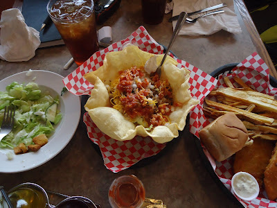
17. The 280-km second stage between Casper and Cheyenne, WY turned out to be the same. There was one service stop in Wheatland, about 180 km from Casper. I ended up riding the 280-km stage without stopping. The fuel indicator showed a reserve status for the last 50 km before arriving in Cheyenne. We stopped at the Exxon gas station just off I-25. The restaurant at the gas station has a very good taco salad. We enjoyed our stop after a long ride.

18. I learned to drink water from the Camelbak my wife carried using the Camelbak tube while riding. It requires coordinated steps to have the tube inserted through my helmet safely. The procedure reminds me of the aerial refueling of a fighter plane by a KC-135, except for our riding the KC-135 would be behind the fighter plane. It would've been very tiring, and I would possibly be dehydrated if I didn't drink water at all. The temperature rose to 41 degree C.

19. The third stage between Cheyenne and Fort Collins, CO (Colorado) was a brief 70 km. The wind subsided once we reached Colorado. In retrospect, the I-25 within Wyoming helps train a riding nerve: the 460-km stretch between Buffalo and Cheyenne was the most desolate highway stretch between Calgary and Fort Collins.

20. We were fortunate to meet a fellow traveller in the gas station who has ridden across the US and gave us a tip to ride through Beartooth Pass in Wyoming when we return to Calgary. I'd keep that route in mind since we seemed to have enough of the big prairie landscape in Montana and Wyoming.

Delicious taco salad at the truck stop in Cheyenne.

Tuesday, June 21, 2016

Helena, MT - Buffalo, WY Motorcycling

On I-90 Highway, between Bozeman, MT and Big Timber, MT.
7. Continuing our Calgary-Helena trip, on Monday June 20 we rode from Helena, MT (Montana) to Buffalo, WY (Wyoming). Total distance this time is 650 km and the gasoline cost is US$20. We left Helena at 10:30 and arrived in Buffalo at 18:30.

8. The relatively low gasoline cost has to do with the F700GS's 800 cc engine and also a cheaper gasoline cost in the US than Canada. It's a fuel-efficient engine although on the road I had wished that the engine were larger for a higher torque at lower rpm. The F700GS has a precise handling on the road to handle twisty sections. Its narrower tires afford a lower steering torque for countersteering.

9. I took Route 287 connecting Helena to the I-90 junction. The 100 km stretch is picturesque along Hauser Lake. Closer to the junction I saw the distant snow-capped mountain range, signaling the Yellowstone National Park area. The route follows Missouri River, which in fact starts at Three Forks, not far from the junction. This is the Missouri River that winds its way through the Midwest to St. Louis, Missouri, where the river merges with Mississippi River.

10. The I-90 highway is pleasant between Three Forks, MT and Bozeman, MT. It has alternating small town and front-range mountain landscapes. It's much less windy as the wind is predominantly eastbound, the same direction as ours. The divided highway gives a welcome change for me.

11. We stopped quickly at a turnout area between Bozeman and Livingston, MT. I had been carrying a Camelbak on my back for 2 days. I asked my wife to carry it since it became a pressure point on my back for our two-up seating and reduced blood flow to my legs. What a big change after I didn't have the Camelbak: I felt much more comfortable and was able to concentrate more on riding.

12. Services between Bozeman and Billings, MT are sparse. A good stop for gasoline and lunch is in Big Timber, about 100 km from Bozeman. I don't remember if there was another stop after Big Timber, until we reached Billings, MT, about 120 km from Big Timber. Billings is an oil city right on the Bakken formation.

13. The landscape changes quickly to a desolate big prairie (steppe) landscape after Billings. The 80-km stretch between Billings and Hardin, MT reminded me of a Nevada landscape, although the latter is mostly desert. The temperature rose to 34 degree C, and we had to soon remove some of our layers to prevent overheating. We stopped for DQ smoothie and ice cream to cool our bodies and remove the layers. My Alberta-riding gloves proved too warm for the 30+ degree C and I had to wear my wife's lighter pair. The glove change improved my riding handling so much.

14. A high plain big prairie landscape between Hardin and Buffalo is magnificent to look at from a motorcycle seat. It is filled with rolling hills that end far away with soaring mountains after a huge flat prairie. I was so relieved to have finally reached Wyoming, after spending 900 km in Montana.

High plain big prairie landscape at the Montana-Wyoming border on the I-90 eastbound.

Monday, June 20, 2016

Calgary - Helena, MT Motorcycling

I-15 Highway, entering Helena, MT, southbound
1. After waiting for the sky to clear, I decided that we go at 10:10 on Sunday, June 19. It was drizzling when we left, and sometimes clouds chased us along Highway 2 southbound. This time we didn't stop in Nanton for refueling. The wind was relatively calm for Highway 2, even after Claresholm toward Fort Macleod.

2. As we rode near Fort Macleod, the crosswind picked up. We refueled there after a 200 km nonstop stretch. Carrying a Camelbak behind my back helps quench my thirst. I didn't have the need to buy a drink at the gas station. The wind gust from the mountain became fierce when we headed southbound along Route 2 from Fort Macleod to Cardston, and then to the Carway US border crossing. My F700GS leaned clockwise about 10 degree to compensate for the crosswind blowing eastbound.

3. The border crossing staff asked where we'd go. I said New Orleans. "Are you going to ride to New Orleans with a motorcycle?" Yes, I reply. He smiled, and pretty soon we passed St. Mary – the gate to the US Glacier National Park – on Route 89. We kept going along twisty mountain curves to reach the fork to Route 287 at Browning. It was chilly along the curves; at times the temperature reached 10 degree C.

4. Route 287 was a good alternative to I-15 Highway between Canada-US border and Great Falls, MT, for motorcycles. It was quiet, not too twisty. We met a couple each riding a Harley from South Carolina when we stopped at Buffalo Joe's in Dupuyer, MT, for lunch. The fried 1/2 chicken at the restaurant was fantastic, highly recommended. We saw the couple dance along the route until Choteau, MT, where we refueled after the 280 km stretch from Fort Macleod.

5. We reached Helena, MT at 18:30 after a 160 km leg from Choteau by continuing on Route 287 and changing to I-15 Highway north of Wolf Creek, MT. 

6. Total gasoline spent for the 640 km trip was US$13 and CD$13. The highlight was the high crosswind section between Fort Macleod and Carway, and also the twisty curves between St. Mary and Browning.